Aug 10, 2011
Unfortunately I have a job that most of the time requires me to work during odd hours.  I was working all day Sunday and didn't get out to the beach until 7pm.  It was heart wrenching to look at the surf cam at 3pm and see everyone having fun on their Sunday off.  All I could do is tell myself there will still be waves when I get off work (an hour before sunset and basically dead low tide).

On the way  I saw cars with boards on their roofs leaving the beach with exhausted occupants inside.  It was a terrible feeling.  When I finally got to the beach it was basically as low as it could get.  Only thing left was a few waist high close out barrels.  But it was still blowing off shore! So I shot a few pictures out of frustration just for you guys, gathered up my board and ran down to the water.  Jumped in and all of a sudden the wind started howling.  Not offshore anymore though.  Straight on.  The stupid jellyfish started stinging me and and by this time everyone was out of the water. I was the only idiot riding, now, waist high mush ball closeouts. 

Don't get me wrong I still had fun so haters don't say, "Kook probably doesn't even surf or go to the beach anymore."  It's easy to tell when everyone is getting frustrated with the surf.  There is a direct correlation to the amount of haters posting on the blog to the amount of days of no surf.  I am glad everyone had fun though.  You needed that.

At least I was making money at work while you people were surfing.

I took 8 pictures at 7pm Sunday.  Three are "worthy" of posting.


Look off the coast of Africa.  Somethings coming...   

MikeC
Aug 7, 2011

T.D. Emily

Signs of Tropical Depression Emily are showing up as I write this.  Only thing is the SW wind is making for some semi choppy conditions.  Let's see what happens as the tide comes up this afternoon.  Yesterday a local storm system rolled through and cleaned things up in a very nice way.  There is a chance for thunderstorms this afternoon so keep an eye out for rapidly cleaning conditions.

MikeC
Aug 5, 2011
Oh yes we can.  The National Hurricane Center (NHC) is giving what remains of Tropical Storm Emily a high chance to form back into a tropical cyclone.  The storm has nearly made it across the high terrain of Hispaniola and now is moving back across warm open waters.  Another good sign is that upper level winds this weekend are looking good to possibly organize Emily once again into a tropical storm.

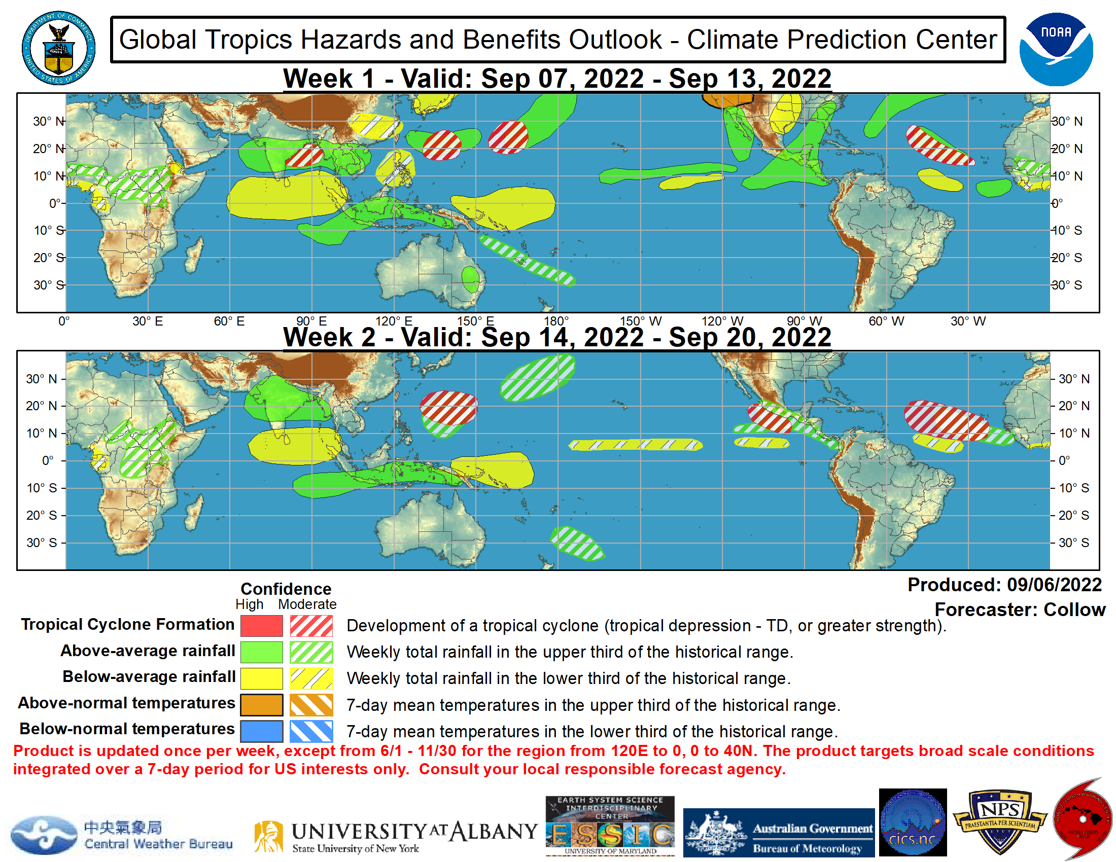
Here is something else to ponder.  The Cape Verde hurricane season is upon us and the Climate Prediction Center is showing signs of it beginning very soon.  Below you can see a large white and red region just off the coast of the Antilles.  This means that there is a a moderate chance for tropical storm formation; AKA things are looking good for storms to form.  Water is warm, air is moist, and upper level winds are looking decent.


All eyes will be watching if Emily can come back from the dead this weekend.

MikeC
Aug 4, 2011

High Terrain Killed Her

There is no longer a defined center.  No longer any convection.  She is sucking dry Saharan air.  And the high terrain of Hispaniola has killed her.   Emily has officially been downgraded to a low pressure trough.

Only thing we can hope for now is for her to drift northward into open water and maybe strengthen.  That's all.

MikeC
Aug 3, 2011

 Emily is currently located just to the South of Hispaniola.  She is moving West at about 14mph.  Sustained winds are at an average of 50mph.  A few problems have sprung up overnight though....

Satellite imagery is showing an off-centered area of circulation.  This is due to unfavorable upper level winds.  Currently the wind is literally shearing off the top of Emily as she moves forward, which is causing her to become a lopsided storm.  Her winds are stronger on the northern side than her south side.  Not good.  We like to see symmetry.  Another problem ahead of her are the high altitude regions of eastern Cuba and Hispaniola which will act as a speed bump.

There is no chance for intensification today.  We need to wait until she makes it over Hispaniola and Cuba.  Thereafter she will be interacting with a trough which will push her on a northerly path over the Bahamas. Conditions will be conducive in this region for slight strengthening/organization. 

What all this means for Folly

As the days progress we can better forecast where Emily will be located once she reaches our coastline.  Right now though there is still MUCH uncertainty of what type of wave conditions we will see.

SATURDAY

What we do know is that Emily will be just to the south of us Saturday morning.  Wave models are showing a longer period swell filling in throughout Saturday.  How big this swell is depends on the intensity of Emily once she crosses over the Bahamas, which is hard to tell.  All we know is that the swell will most likely be building all Saturday.  Local winds Saturday are expected to be light out of the South.  Slight bump on the water.

SUNDAY

Sunday Emily is expected to be parallel to our coastline.  It is during this time we will be experiencing most of Emily's gift of waves.  Swell charts are low-balling wave heights because there is still an area of uncertainty of her location and intensity as I've said before.  Nonetheless wave heights are expected to be in the 4+ft range.  And since this will be a longer period swell; the waves will have a little punch.  Local winds Sunday are expected to also be light out of the SW.  Again well see a slight bump on the water.

MONDAY

Monday could be our clean up day.  Ha ha for all of you that need to work.  Listen though, Monday is far away but the winds are looking decent at least.  We might see some leftover swell in the 3ft range.  

Lets see what unfolds.

MikeC
Aug 2, 2011

We Need to Watch Emily

Currently, computer models are forecasting Emily to come very close to our coastline towards the end of the weekend.  Some models are predicting she could be come a category 1 storm.  She is still far away but residents from North Carolina to Florida need to keep a close eye on her path.

Nothing much has changed overnight in terms of organization.  If anything she has slowed and began to meander a bit.  Later today she will get back on track moving W NW with little strengthening expected due to some drier weather ahead of her.  Later this week she is expected to be impacted by a trough forcing her on a more northerly path; straight toward us.

If she gets too close to us the surf is going to be stormy and we'll probably experience some heavy rains and coastal flooding.  But if she stays off our coast we could see a quick shot of surf.  Emily will be moving at a quick pace by the time she reaches our coast so unless Emily stalls out the surf won't last long.


Right now it's hard to tell what kind of surf we will get because it is hard to tell how close she will get to the coast.  I'm assuming that is why many of the forecast sites are calling for nothing right now.

Remember though, to keep a close eye on this storm as we get closer to the weekend.

MikeC
Aug 1, 2011
So much for saying Emily will just 'skirt' along the islands of the Caribbean Sea.  Looks like she is going to blast her way across all of them.  Flooding is expected for most of the islands.  Don't go off and buy your tickets to Puerto Rico.  This isn't the storm. 

Maximum sustained winds are currently 40mph gusting to around 50mph.  Emily will be traveling over a mix of land and water over the next week which will stifle any real development.  Nonetheless upper level conditions remain favorable so she is expected to hold her tropical storm title until reaching mostly open waters South of the Bahamas.  When she reaches that point she is expected to form into a hurricane due to the 90 plus degree Caribbean Sea, possibly impacting the Bahamas and southern Florida.

After possibly impacting S. Florida she is expected to turn more northerly, away from the US coastline.  This is all going to happen later this weekend into next week.  Depending how she impacts S. Florida and how close/far she gets from our coast, will depend on what type of waves we get.

Keep an eye on the tropics everyone.

MikeC